
Phosphorus, Hotspots, and Sustainable Water Management
What are phosphorus hotspots in watersheds and how to manage them to improve water quality?
Balance is important when it comes to phosphorus—excess levels can cause major water quality issues. It’s critical to identify phosphorus sources on the landscape (or “hotspots”) and target these specific regions with focused solutions. Before creating these tailored solutions, understanding how to find the hotspots and estimate their impact is crucial. Only then can we determine the best steps forward to reduce excess nutrients and improve freshwater quality.
What are phosphorus hotspots and why do they matter?
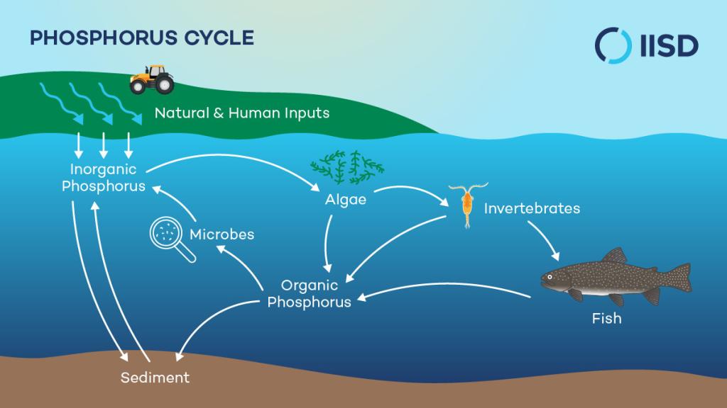
Phosphorus is an essential nutrient for all living things, found in minerals, soils, and living organisms. If concentrations are too high, however, it can set off a devastating chain of events in freshwater systems. Lakes need phosphorus to thrive; it is a driver of primary productivity and a major component of DNA and cells.
However, too much of this nutrient can cause large algal blooms, which, when they decay, can drain the oxygen from a lake, leading to asphyxiation of fish and other life forms. This form of ecosystem degradation is known as eutrophication and is typically caused by human activity.
In fact, research at IISD Experimental Lakes Area first identified phosphorus as the key driver of algal blooms. It was their first-ever research project back in the 1960s and changed environmental laws around the globe; its scientists have worked ever since to reduce how much of it ends up in our freshwater systems.
Some algal blooms can be toxic to humans, pets, fish, and other aquatic organisms. These harmful algal blooms decimate ecosystems and prevent lakes and rivers from being used for recreational and commercial purposes such as fishing, boating, and swimming.
Identifying geographic areas that consistently export high amounts of phosphorus to the surrounding landscape, also known as phosphorus hotspots, is an important step towards reducing nutrient pollution in freshwater environments.
Where does phosphorus come from?
Phosphorus can make its way into rivers and lakes through many different means. The phosphorus cycle describes how phosphorus moves through a natural environment and interacts with organisms like microbes, algae, fish, and invertebrates. Natural sources of phosphorus include the leaching of minerals, as well as the periodic release of phosphorus retained in sediment reserves at the bottom of a lake.
Human activities also contribute phosphorus to freshwater environments—often far outweighing natural sources.
Anthropogenic (human-caused) nutrient pollution can be placed into two categories: point source (PS) and non-point source (NPS) pollution:
PS pollution comes from a distinct, identifiable source that typically releases pollution directly into waterways. These sources include wastewater treatment plants, livestock farms, factories, and mines.
NPS pollution is more difficult to track because it can come from many dispersed sources that are difficult to identify. This type of pollution enters waterways indirectly through land runoff that gradually accumulates nutrients as it moves across the landscape before depositing them into waterways. Examples of NPS pollution include the application of fertilizers and pesticides on agricultural lands, as well as stormwater draining from urban areas.
There are many other factors that influence phosphorus concentrations in our lakes and rivers. The amount and type of precipitation and runoff, as well as the local soil and vegetation on the landscape, help determine how much phosphorus is washed into our waterways from non-point sources. Forested areas are more protected against erosion and runoff due to the presence of tree canopies and roots, which slow rainfall and absorb water. Urban and agricultural areas are much more susceptible to runoff and export higher amounts of phosphorus than other land uses due to the phosphorus content in fertilizers, livestock waste, and sewage. Land-use change can, therefore, influence phosphorus exports from a landscape. Other factors include the geology (bedrock) and topography (the shape and slope of the landscape) in a particular region.
How are phosphorus hotspots identified?
The problem is that researchers don’t have access to reliable data on human impacts on freshwater environments, particularly nutrient pollution from non-point sources. Actionable insights on phosphorus hotspots require long-term, continuous data obtained from multiple lakes and rivers in each watershed.
Provincial and federal governments have been monitoring some of Canada’s 100 sub-watersheds for years, but in many areas, water quality data for this type of research is still lacking. Community-based water monitoring has emerged as a successful method for filling some of these data gaps by engaging and empowering local organizations and citizens to increase monitoring and surveillance of freshwater resources within their community.
In Manitoba, the Lake Winnipeg Foundation (LWF) was founded to advocate for change and coordinate action to reduce phosphorus pollution to Lake Winnipeg. LWF coordinates the Lake Winnipeg Community-Based Monitoring Network (LWCBMN), which mobilizes volunteers and watershed district partners to collect water samples for phosphorus testing from across the province. Water samples collected are analyzed in a lab, and the resulting concentration data is used to calculate the total amount of phosphorus exported from lands upstream (the “phosphorus export”) for the year. Comparing these results over multiple years allows LWF to identify persistent phosphorus hotspots in Manitoba.
This data also helps researchers and policy-makers to better understand phosphorus hotspots through modelling. Water quality models can combine measured phosphorus concentration data with other information, like weather and land-use data, to estimate the sources and sinks of phosphorus within a watershed. Modelling can also be used to evaluate the phosphorus removed through new practices or policy measures within the watershed.
How does identifying hotspots help us to manage phosphorus?
Identifying phosphorus hotspots helps pinpoint areas of concern so that researchers and watershed districts can take action to improve locations that will make the greatest impact.
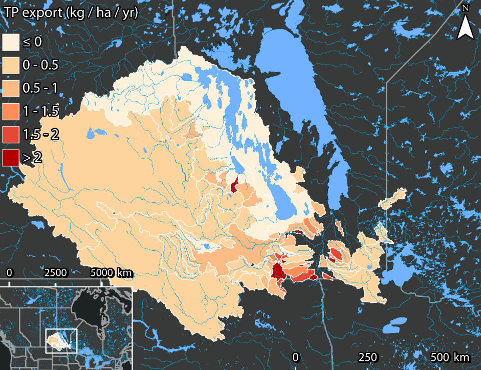
Using publicly available data from the 2016 Census of Agriculture, IISD researchers were able to identify three hotspots in Manitoba: southwest Red River Valley, southeast Red River Valley, and southwestern Manitoba. They could focus their analysis on these three regions and identify several causes of poor water quality, including high fertilizer application rates, manure being applied on farmed acres without incorporating it into the soil, and high prevalence of conservation tillage (low- or no-tillage) practices.
Once phosphorus hotspots are identified, researchers can design strategies to meet the needs of each case. For example, beneficial management practices (BMPs) can be implemented on agricultural lands to reduce nutrient runoff. There are many different types of BMPs that can be used to address nutrient pollution from a farm. Some examples include planting vegetation buffers, conservation tillage, crop rotation, and timing manure applications.
The effectiveness of BMPs is variable and depends heavily on the specific conditions of the site to which they are applied. Applying BMPs generally to an entire province would not successfully reduce phosphorus exports everywhere and may even increase exports in some areas. Identifying phosphorus hotspots enables researchers to narrow their study area and focus on regions where implementing BMPs would be most beneficial.
How can we mitigate phosphorus hotspots?
Each watershed contributes to excess nutrient pollution for a different reason; therefore, effective BMPs and other water management strategies will be different for each hotspot.
IISD has identified several strategies that can be employed in phosphorus hotspots of Manitoba, depending on the circumstances and conditions of each site. For example, areas with a high proportion of fertilizer application, such as the Southwest Red River Valley, would likely benefit from natural infrastructure solutions, such as engineered wetlands. Cattails in wetlands take up phosphorus and can then be harvested for biomass, permanently removing phosphorus from the landscape. In the Southeast Red River Valley, the lack of manure incorporation into the soil increases the risk of runoff during seasonal storms. Policy interventions that encourage producers to incorporate manure into their soil could benefit water quality in this region. Parts of the Assiniboine River in Southwestern Manitoba have been identified as phosphorus hotspots due to the high concentration of conservation tillage in this area, a method that improves soil health but can increase phosphorus runoff. BMPs such as vegetation buffers and retention ditches could remove some of the excess phosphorus caused by this method of tillage.
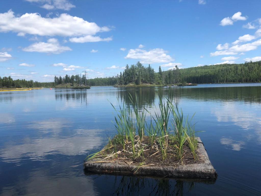
IISD has also been developing and testing natural infrastructure strategies at IISD Experimental Lakes Area in Ontario and applying these strategies in practice in parts of Manitoba. Floating treatment wetlands (FTWs) are an example of a natural infrastructure strategy that could greatly benefit phosphorus hotspots. These small artificial islands create miniature wetlands that take up nutrients and reduce turbulence. They can be placed in stormwater ponds, wastewater lagoons, tailings ponds, and even oil spill sites. Results have shown that FTWs can significantly increase the productivity of cattail plants in lakes with excess phosphorus.
Monitoring and reducing phosphorus loads are essential to protecting fresh water.
As humans reshape our landscape to build our cities and grow our food, we often disrupt the nutrient cycle in our lakes and rivers. There are measures we can take to help reduce this phosphorus loading and the eutrophication of lakes like Lake Winnipeg, but it’s important that we know where to focus our attention and resources.
Identifying phosphorus hotspots is an essential step towards successfully implementing measures like beneficial management practices and natural infrastructure. Data collected by volunteers and researchers, or generated with the help of watershed models, can help decision-makers to direct their efforts strategically and achieve the greatest impact.

You might also be interested in
Over a Decade of Protecting the World's Fresh Water: Five ways IISD Experimental Lakes Area has made a difference
The Experimental Lakes Area has been transformed ever since IISD saved it from imminent closure. But, don’t just take our word for it. Here are five stories from people who have seen, firsthand, the impact of IISD-ELA over the last decade.
Making the most of water
Scorching droughts that wither crops and pasture, torrential rains that flood fields, and storms that wash out roads. These events don’t just impact yields, they also threaten the livelihoods and well-being of everyday citizens, writes IISD expert Ashley Rawluk.
Northern Ontario's renowned freshwater lab gets an upgrade
By this time next year, staff scientists at northwestern Ontario's renowned IISD-ELA will be settled into a brand-new home—one that's been nearly a decade in the making. Currently under construction, IISD-ELA is building the mass-timber, 10,000-square-foot Centre for Climate and Lake Learning.
Treaty 3 team deploys new water monitoring devices across territory
IISD Experimental Lakes Area offered support to Grand Council Treaty 3 when it first launched its monitoring program, having done water quality work for decades.