
Emerging Stories of Big Data for Resilience Building: Dar Ramani Huria
In the unplanned and informal settlements that abound in Dar es Salaam, flooding causes heavy losses in livelihoods and infrastructure. What does Big Data have to do with this?
The day started like any other day in the Tandale ward of Dar es Salaam, Tanzania.
It was the middle of the rainy season, and the situation could deteriorate quickly. The water level in the nearby stream was rising dangerously, and the roads were becoming impassable due to heavy rain and mud. A flood was imminent, and community members needed to take action.
The memories of last year’s flooding were still fresh in their minds. Hospitals and schools had been closed, and businesses had been forced to halt their operations. Just last month, flooded homes and roads caused at least nine casualties. In the unplanned and informal settlements that abound in Dar es Salaam, flooding also causes heavy losses in livelihoods and infrastructure.
What does Big Data have to do with this story?
A few years ago, probably nothing. Maps were unavailable, and if available, were often inaccurate, outdated, or contained insufficient data for planning and decision making in the event of disasters. But today, thanks to the efforts of hundreds of community mapping volunteers, Big Data is playing a role in local resilience to flooding and improving the ability of at-risk communities to prepare for, respond to and adapt to its impacts.
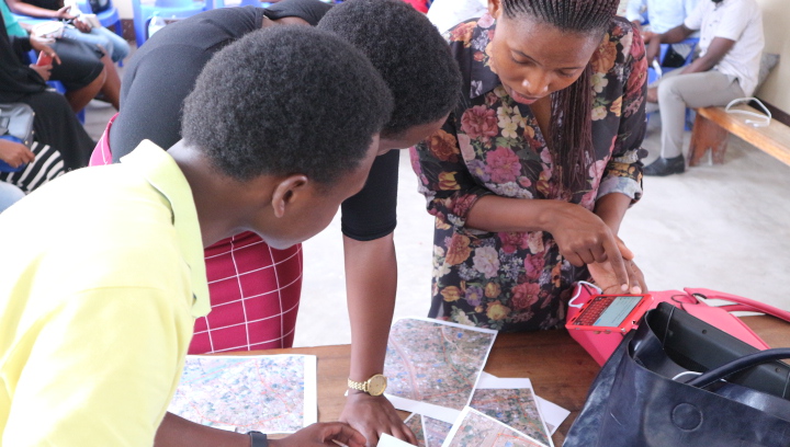
Community-based maps can be powerful tools for change. Trainings offered by the Dar Ramani Huria initiative[i] (Swahili for “Dar Open Map”) are building local capacities to collect local data through multiple methods and tools and to develop maps by digitizing their content via OpenStreetMap. Community members are now better informed about the risks in flood-prone areas, are able to access up-to-date community-based maps to get a better sense of the extent and impact of a flood, and know who to contact in order to coordinate response actions.
In case of a disaster like a flood, the maps help us a lot because with the maps you can see where the valleys are and how many houses are in it, how many houses are in the danger zone, and how many houses are in the safe zone. So by looking at the map it is easier to be prepared in case of disasters. —Julianna Letara, City Planner, Kinondoni
Stories at the intersection of Big Data and resilience building are emerging across the world. A recent IISD publication examines the experiences of six international organizations that are actively using Big Data to strengthen the resilience of vulnerable communities and ecosystems to a variety of shocks and stressors.
How Does Dar Ramani Huria Build Resilience?
Open community-based maps help build coping and adaptive capacities by:
- Providing decision-makers and communities with detailed maps of areas, roads, streams, floodplains and other relevant features to strengthen risk identification and awareness-raising about climate risk and uncertainty.
- Equipping community members and ward leaders with the skills required for data mapping, digitizing and modelling risk. The skills acquired by mappers are widely applicable to a number of areas, contributing to their ability to diversify their livelihood options and adapt to change.
Learn more about Dar Ramani Huria in the Big Data for Resilience Storybook
Lessons Learned
Many valuable lessons have emerged from this initiative. Among them:
- Connecting Big Data with local actions through partnerships with communities and local leaders is key. Dar Ramani Huria works with sub-ward level leaders, geotagging contextual information such as vulnerable groups, risk areas, waste, community assets and community “comments” on risk management. More in-depth geocoded data layers developed with communities feed into broader community dialogue, risk reduction strategies and planning processes.
- Ensuring data quality through multiple data assurance mechanisms is vital to building trust and enabling informed decision-making. Dar Ramani Huria reviews and tests new methods and technologies on a constant basis, enabling local teams to detect problems on time, identify cost-effective solutions and innovate in order to ensure the highest data quality.
- The use of free/open source software can enable cost-effective and sustainable community-based approaches to resilience. The use of free and open source software and local devices (students trained by Dar Ramani Huria on smartphones) means that everything needed to continue the project and keep data updated as the city changes is already available in the community.
One of the biggest misconceptions about the role of Big Data in international development is intrinsic to its name: Big Data’s potential for resilience building is not about volume or technological capabilities. It’s about human stories. It’s about how data is accessed, analyzed and effectively used to inform decision-making processes in order to strengthen development pathways.
Big Data’s contribution to resilience depends on our ability as development and resilience practitioners, as researchers and decision-makers, to leverage the vast amount of digital data that is constantly being generated and use it effectively to improve the resilience of vulnerable communities.
Photos: ©Humanitarian OpenStreetMap Team
[i] Strengthening Urban Resilience Through Community-based Mapping: Dar Ramani Huria (World Bank funded by the UK Department for International Development (DFID) in partnership with Humanitarian OpenStreetMap Team, Tanzania Red Cross, Ardhi University, and the City of Dar es Salaam)
You might also be interested in
Big Data for Resilience
Summary of a recent event looking at the links between Big Data, resilience and achieving long-term development goals, and the implications for practitioners, policy-makers and researchers.
Five Ways Blockchain Technology Can be Used for Resilience
Disruptive technology has vast applications toward increasing the resilience of individuals, communities and ecosystems. Here are five encouraging examples.
High-tech data needed to stop sewage overflows
Financial sector technology could help as cities struggle with waste.
Big Data for Resilience Storybook
The Big Data for Resilience Storybook explores the links between Big Data and resilience building through the experiences of seven international organizations.